


A hiker was rescued from a cliff on Canada’s Mount Fromme over the weekend after rescuers say he may have become stranded while trying to follow a "non-existent trail" shown on Google Maps.
A helicopter rescue crew and rope team responded to the backside of Mount Fromme, located near Vancouver, British Columbia, late Saturday afternoon, North Shore Rescue said.
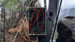
The hiker had attempted to climb the mountain from the Kennedy Falls area, which officials described as having no trails, being very steep with cliff bands throughout and was the site of a previous fatality.
Rescuers, however, were unable to spot the stranded hiker by air due to a dense tree canopy covering the area. Officials said the hiker was ill-prepared for the trek, having no flashlight to wave down rescuers and having minimal gear.
UTAH CLIMBER RESCUED AFTER GETTING STUCK IN CLIFF FACE CRACK FOR 12 HOURS
Rescuers decided to lower two helicopter rescue technicians onto the mountain about 330 feet (100 meters) below, where they believed the individual was stuck. Low cloud conditions prevented the chopped from flying any higher.
The two rescuers made their way up the difficult terrain on a roped belay and were eventually able to find the hiker. The rescuers put the hiker into a harness and brought him safely down to a location where the helicopter could extract all three before the low clouds completely covered the area.
Officials said there were several "lessons learned" from the situation.
"First, it is simply not appropriate to navigate in the wilderness using ‘urban street map’ programs like Google Maps," the rescue group said.
ARIZONA HIKERS DISCOVER BODY OF MISSING WOMAN NEAR MOUNTAIN PEAK
Officials recommended using "the good old-fashioned" paper map and compass and adhering to signs posted in the area in previous weeks to warn hikers of the dangers in the area.
If hikers are to use a phone-based navigation app, officials recommended using one designed for the outdoors and is preloaded with an appropriate wilderness topographical map.
Crews previously rescued another hiker in the same area in September, saying that the individual had also appeared to try following a trail on Google Maps that does not exist, officials said.
The rescue group said it has tried contacting Google to have the non-existent trail removed from Google Maps but has yet to receive a response.
Fox News Digital reached out to Google for comment but did not immediately hear back.
